|
|
|||||||||||||||||
| Point ID: 800 | Downloads | Plots | Site Data | Code: 07KA002 |
|
|
|||||||||||||||||
| Download | |
|---|---|
| Site Descriptor Information | Site Time Series Data |
| Link to all available data | |
| View: | Time Series | All |
| Units: | mm |
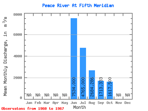
| Statistic | Jan | Feb | Mar | Apr | May | Jun | Jul | Aug | Sep | Oct | Nov | Dec | Annual |
|---|---|---|---|---|---|---|---|---|---|---|---|---|---|
| Mean | 7534.00 | 4765.00 | 2684.29 | 1713.33 | 1617.50 | ||||||||
| Standard Deviation | 1154.87 | 1294.06 | 1480.63 | 465.73 | 417.96 | ||||||||
| Min | 6550.00 | 2890.00 | 1190.00 | 1110.00 | 1370.00 | ||||||||
| Max | 8980.00 | 6030.00 | 5690.00 | 2170.00 | 2240.00 | ||||||||
| Coefficient of Variation | 0.15 | 0.27 | 0.55 | 0.27 | 0.26 |
 Return to R-Arctic Net Home Page