|
|
|||||||||||||||||
| Point ID: 7968 | Downloads | Plots | Site Data | Code: 3609 |
|
|
|||||||||||||||||
| Download | |
|---|---|
| Site Descriptor Information | Site Time Series Data |
| Link to all available data | |
| View: | Time Series | All |
| Units: | mm |
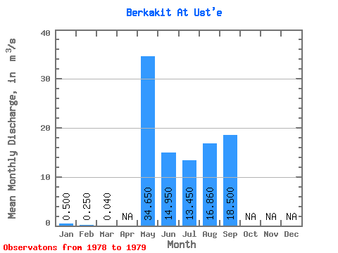
| Statistic | Jan | Feb | Mar | Apr | May | Jun | Jul | Aug | Sep | Oct | Nov | Dec | Annual |
|---|---|---|---|---|---|---|---|---|---|---|---|---|---|
| Mean | 0.50 | 0.25 | 0.04 | 34.65 | 14.95 | 13.45 | 16.86 | 18.50 | |||||
| Standard Deviation | 7.00 | 6.86 | 8.41 | 16.04 | |||||||||
| Min | 0.50 | 0.25 | 0.04 | 29.70 | 10.10 | 7.50 | 5.52 | 18.50 | |||||
| Max | 0.50 | 0.25 | 0.04 | 39.60 | 19.80 | 19.40 | 28.20 | 18.50 | |||||
| Coefficient of Variation | 0.20 | 0.46 | 0.63 | 0.95 |
 Return to R-Arctic Net Home Page