|
|
|||||||||||||||||
| Point ID: 7928 | Downloads | Plots | Site Data | Code: 3515 |
|
|
|||||||||||||||||
| Download | |
|---|---|
| Site Descriptor Information | Site Time Series Data |
| Link to all available data | |
| View: | Time Series | All |
| Units: | mm |
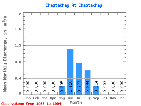
| Statistic | Jan | Feb | Mar | Apr | May | Jun | Jul | Aug | Sep | Oct | Nov | Dec | Annual |
|---|---|---|---|---|---|---|---|---|---|---|---|---|---|
| Mean | 0.00 | 0.00 | 0.00 | 0.00 | 0.20 | 1.11 | 0.78 | 0.59 | 0.21 | 0.01 | 0.00 | 0.00 | 0.24 |
| Standard Deviation | 0.00 | 0.00 | 0.00 | 0.00 | 0.24 | 0.56 | 0.30 | 0.29 | 0.16 | 0.01 | 0.00 | 0.00 | 0.07 |
| Min | 0.00 | 0.00 | 0.00 | 0.00 | 0.01 | 0.32 | 0.23 | 0.14 | 0.03 | 0.00 | 0.00 | 0.00 | 0.15 |
| Max | 0.00 | 0.00 | 0.00 | 0.00 | 1.15 | 3.13 | 1.37 | 1.15 | 0.62 | 0.07 | 0.00 | 0.00 | 0.39 |
| Coefficient of Variation | 1.19 | 0.51 | 0.39 | 0.48 | 0.73 | 1.86 | 0.30 |
 Return to R-Arctic Net Home Page