|
|
|||||||||||||||||
| Point ID: 7910 | Downloads | Plots | Site Data | Code: 3433 |
|
|
|||||||||||||||||
| Download | |
|---|---|
| Site Descriptor Information | Site Time Series Data |
| Link to all available data | |
| View: | Time Series | All |
| Units: | mm |
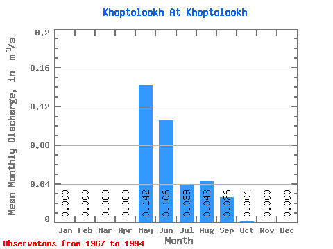
| Statistic | Jan | Feb | Mar | Apr | May | Jun | Jul | Aug | Sep | Oct | Nov | Dec | Annual |
|---|---|---|---|---|---|---|---|---|---|---|---|---|---|
| Mean | 0.00 | 0.00 | 0.00 | 0.00 | 0.14 | 0.11 | 0.04 | 0.04 | 0.03 | 0.00 | 0.00 | 0.00 | 0.03 |
| Standard Deviation | 0.00 | 0.00 | 0.00 | 0.00 | 0.14 | 0.14 | 0.07 | 0.08 | 0.04 | 0.00 | 0.00 | 0.00 | 0.03 |
| Min | 0.00 | 0.00 | 0.00 | 0.00 | 0.00 | 0.00 | 0.00 | -0.06 | -0.02 | 0.00 | 0.00 | 0.00 | 0.00 |
| Max | 0.00 | 0.00 | 0.00 | 0.00 | 0.48 | 0.42 | 0.35 | 0.26 | 0.12 | 0.01 | 0.00 | 0.00 | 0.12 |
| Coefficient of Variation | 0.97 | 1.30 | 1.85 | 1.81 | 1.38 | 2.36 | 1.08 |
 Return to R-Arctic Net Home Page