|
|
|||||||||||||||||
| Point ID: 79 | Downloads | Plots | Site Data | Code: 05AC902 |
|
|
|||||||||||||||||
| Download | |
|---|---|
| Site Descriptor Information | Site Time Series Data |
| Link to all available data | |
| View: | Time Series | All |
| Units: | mm |
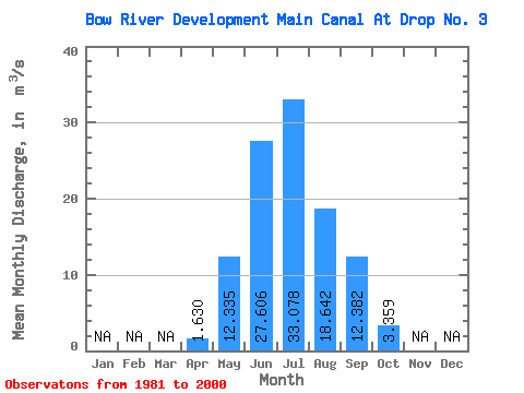
| Statistic | Jan | Feb | Mar | Apr | May | Jun | Jul | Aug | Sep | Oct | Nov | Dec | Annual |
|---|---|---|---|---|---|---|---|---|---|---|---|---|---|
| Mean | 1.63 | 12.34 | 27.61 | 33.08 | 18.64 | 12.38 | 3.36 | ||||||
| Standard Deviation | 1.96 | 9.04 | 6.20 | 8.55 | 3.66 | 5.04 | 2.02 | ||||||
| Min | 0.00 | 3.63 | 14.90 | 16.30 | 9.95 | 4.51 | 0.99 | ||||||
| Max | 4.83 | 35.40 | 37.70 | 44.30 | 24.70 | 21.20 | 8.02 | ||||||
| Coefficient of Variation | 1.21 | 0.73 | 0.23 | 0.26 | 0.20 | 0.41 | 0.60 |
 Return to R-Arctic Net Home Page