|
|
|||||||||||||||||
| Point ID: 7899 | Downloads | Plots | Site Data | Code: 3393 |
|
|
|||||||||||||||||
| Download | |
|---|---|
| Site Descriptor Information | Site Time Series Data |
| Link to all available data | |
| View: | Time Series | All |
| Units: | mm |
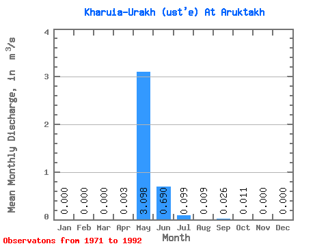
| Statistic | Jan | Feb | Mar | Apr | May | Jun | Jul | Aug | Sep | Oct | Nov | Dec | Annual |
|---|---|---|---|---|---|---|---|---|---|---|---|---|---|
| Mean | 0.00 | 0.00 | 0.00 | 0.00 | 3.10 | 0.69 | 0.10 | 0.01 | 0.03 | 0.01 | 0.00 | 0.00 | 0.26 |
| Standard Deviation | 0.00 | 0.00 | 0.00 | 0.01 | 2.84 | 0.66 | 0.19 | 0.02 | 0.09 | 0.04 | 0.00 | 0.00 | 0.26 |
| Min | 0.00 | 0.00 | 0.00 | 0.00 | 0.03 | 0.00 | 0.00 | 0.00 | 0.00 | 0.00 | 0.00 | 0.00 | 0.00 |
| Max | 0.00 | 0.00 | 0.00 | 0.01 | 8.41 | 2.18 | 0.70 | 0.09 | 0.34 | 0.16 | 0.00 | 0.00 | 0.77 |
| Coefficient of Variation | 1.77 | 0.92 | 0.95 | 1.91 | 2.69 | 3.57 | 3.74 | 1.00 |
 Return to R-Arctic Net Home Page