|
|
|||||||||||||||||
| Point ID: 7897 | Downloads | Plots | Site Data | Code: 3387 |
|
|
|||||||||||||||||
| Download | |
|---|---|
| Site Descriptor Information | Site Time Series Data |
| Link to all available data | |
| View: | Time Series | All |
| Units: | mm |
| Statistic | Jan | Feb | Mar | Apr | May | Jun | Jul | Aug | Sep | Oct | Nov | Dec | Annual |
|---|---|---|---|---|---|---|---|---|---|---|---|---|---|
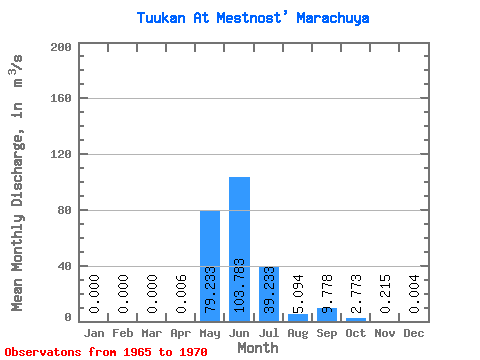
| Mean | 0.00 | 0.00 | 0.00 | 0.01 | 79.23 | 103.78 | 39.23 | 5.09 | 9.78 | 2.77 | 0.21 | 0.00 | 19.55 |
| Standard Deviation | 0.00 | 0.00 | 0.00 | 0.02 | 69.01 | 54.69 | 49.05 | 6.14 | 8.95 | 3.54 | 0.37 | 0.01 | 11.38 |
| Min | 0.00 | 0.00 | 0.00 | 0.00 | 14.30 | 60.20 | 11.50 | 0.45 | 0.25 | 0.28 | 0.01 | 0.00 | 8.62 |
| Max | 0.00 | 0.00 | 0.00 | 0.04 | 202.00 | 193.00 | 138.00 | 15.60 | 21.00 | 7.90 | 0.77 | 0.01 | 35.53 |
| Coefficient of Variation | 2.45 | 0.87 | 0.53 | 1.25 | 1.21 | 0.92 | 1.28 | 1.73 | 2.00 | 0.58 |
 Return to R-Arctic Net Home Page