|
|
|||||||||||||||||
| Point ID: 7892 | Downloads | Plots | Site Data | Code: 3377 |
|
|
|||||||||||||||||
| Download | |
|---|---|
| Site Descriptor Information | Site Time Series Data |
| Link to all available data | |
| View: | Time Series | All |
| Units: | mm |
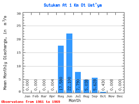
| Statistic | Jan | Feb | Mar | Apr | May | Jun | Jul | Aug | Sep | Oct | Nov | Dec | Annual |
|---|---|---|---|---|---|---|---|---|---|---|---|---|---|
| Mean | 0.00 | 0.00 | 0.00 | 0.00 | 17.58 | 22.10 | 7.79 | 5.04 | 5.63 | 0.43 | 0.01 | 0.00 | 4.88 |
| Standard Deviation | 0.00 | 0.00 | 0.00 | 0.01 | 7.65 | 6.29 | 6.61 | 7.87 | 3.01 | 0.33 | 0.02 | 0.00 | 1.43 |
| Min | 0.00 | 0.00 | 0.00 | 0.00 | 10.60 | 13.30 | 0.82 | 0.02 | 1.07 | 0.03 | 0.00 | 0.00 | 3.09 |
| Max | 0.00 | 0.00 | 0.00 | 0.02 | 30.10 | 30.70 | 18.20 | 19.00 | 8.55 | 0.75 | 0.04 | 0.00 | 6.97 |
| Coefficient of Variation | 2.24 | 0.43 | 0.28 | 0.85 | 1.56 | 0.54 | 0.76 | 2.24 | 0.29 |
 Return to R-Arctic Net Home Page