|
|
|||||||||||||||||
| Point ID: 7859 | Downloads | Plots | Site Data | Code: 3290 |
|
|
|||||||||||||||||
| Download | |
|---|---|
| Site Descriptor Information | Site Time Series Data |
| Link to all available data | |
| View: | Time Series | All |
| Units: | mm |
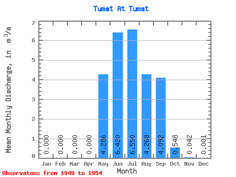
| Statistic | Jan | Feb | Mar | Apr | May | Jun | Jul | Aug | Sep | Oct | Nov | Dec | Annual |
|---|---|---|---|---|---|---|---|---|---|---|---|---|---|
| Mean | 0.00 | 0.00 | 0.00 | 0.00 | 4.29 | 6.42 | 6.55 | 4.27 | 4.09 | 0.55 | 0.04 | 0.00 | 2.27 |
| Standard Deviation | 0.00 | 0.00 | 0.00 | 0.00 | 1.46 | 4.48 | 3.89 | 2.09 | 3.17 | 0.37 | 0.02 | 0.00 | 0.83 |
| Min | 0.00 | 0.00 | 0.00 | 0.00 | 2.86 | 2.77 | 1.36 | 1.49 | 0.50 | 0.11 | 0.02 | 0.00 | 0.89 |
| Max | 0.00 | 0.00 | 0.00 | 0.00 | 6.42 | 11.50 | 12.10 | 6.16 | 7.97 | 1.20 | 0.08 | 0.01 | 3.10 |
| Coefficient of Variation | 0.34 | 0.70 | 0.59 | 0.49 | 0.78 | 0.67 | 0.51 | 2.10 | 0.37 |
 Return to R-Arctic Net Home Page