|
|
|||||||||||||||||
| Point ID: 7853 | Downloads | Plots | Site Data | Code: 3265 |
|
|
|||||||||||||||||
| Download | |
|---|---|
| Site Descriptor Information | Site Time Series Data |
| Link to all available data | |
| View: | Time Series | All |
| Units: | mm |
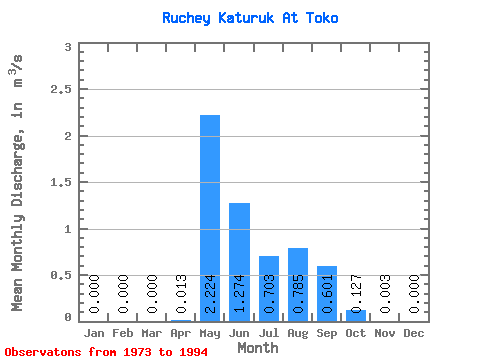
| Statistic | Jan | Feb | Mar | Apr | May | Jun | Jul | Aug | Sep | Oct | Nov | Dec | Annual |
|---|---|---|---|---|---|---|---|---|---|---|---|---|---|
| Mean | 0.00 | 0.00 | 0.00 | 0.01 | 2.22 | 1.27 | 0.70 | 0.79 | 0.60 | 0.13 | 0.00 | 0.00 | 0.51 |
| Standard Deviation | 0.00 | 0.00 | 0.00 | 0.04 | 1.01 | 1.59 | 0.63 | 0.57 | 0.37 | 0.09 | 0.01 | 0.00 | 0.17 |
| Min | 0.00 | 0.00 | 0.00 | 0.00 | 0.85 | 0.33 | 0.06 | 0.12 | 0.16 | 0.00 | 0.00 | 0.00 | 0.32 |
| Max | 0.00 | 0.00 | 0.00 | 0.15 | 5.96 | 7.67 | 2.19 | 2.21 | 1.26 | 0.30 | 0.03 | 0.00 | 0.95 |
| Coefficient of Variation | 3.08 | 0.46 | 1.25 | 0.90 | 0.72 | 0.62 | 0.71 | 2.33 | 0.32 |
 Return to R-Arctic Net Home Page