|
|
|||||||||||||||||
| Point ID: 7847 | Downloads | Plots | Site Data | Code: 3258 |
|
|
|||||||||||||||||
| Download | |
|---|---|
| Site Descriptor Information | Site Time Series Data |
| Link to all available data | |
| View: | Time Series | All |
| Units: | mm |
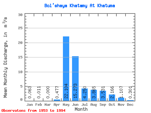
| Statistic | Jan | Feb | Mar | Apr | May | Jun | Jul | Aug | Sep | Oct | Nov | Dec | Annual |
|---|---|---|---|---|---|---|---|---|---|---|---|---|---|
| Mean | 0.06 | 0.01 | 0.00 | 0.48 | 22.10 | 15.27 | 4.25 | 3.87 | 3.53 | 2.17 | 1.11 | 0.30 | 4.54 |
| Standard Deviation | 0.21 | 0.07 | 0.00 | 1.30 | 11.32 | 10.78 | 3.06 | 2.77 | 1.68 | 1.19 | 0.89 | 0.53 | 1.47 |
| Min | 0.00 | 0.00 | 0.00 | 0.00 | 5.52 | 2.06 | 0.90 | 0.76 | 0.76 | 0.42 | 0.03 | 0.00 | 2.67 |
| Max | 1.07 | 0.38 | 0.00 | 7.02 | 62.80 | 40.70 | 16.20 | 10.70 | 7.85 | 5.18 | 3.25 | 1.84 | 8.97 |
| Coefficient of Variation | 3.28 | 5.83 | 5.83 | 2.73 | 0.51 | 0.71 | 0.72 | 0.72 | 0.47 | 0.55 | 0.80 | 1.75 | 0.32 |
 Return to R-Arctic Net Home Page