|
|
|||||||||||||||||
| Point ID: 7832 | Downloads | Plots | Site Data | Code: 3203 |
|
|
|||||||||||||||||
| Download | |
|---|---|
| Site Descriptor Information | Site Time Series Data |
| Link to all available data | |
| View: | Time Series | All |
| Units: | mm |
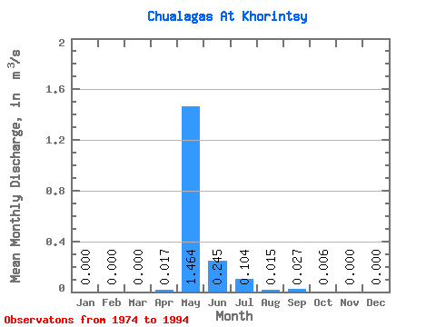
| Statistic | Jan | Feb | Mar | Apr | May | Jun | Jul | Aug | Sep | Oct | Nov | Dec | Annual |
|---|---|---|---|---|---|---|---|---|---|---|---|---|---|
| Mean | 0.00 | 0.00 | 0.00 | 0.02 | 1.46 | 0.24 | 0.10 | 0.01 | 0.03 | 0.01 | 0.00 | 0.00 | 0.17 |
| Standard Deviation | 0.00 | 0.00 | 0.00 | 0.03 | 0.73 | 0.28 | 0.20 | 0.03 | 0.05 | 0.01 | 0.00 | 0.00 | 0.09 |
| Min | 0.00 | 0.00 | 0.00 | 0.00 | 0.36 | 0.00 | 0.00 | 0.00 | 0.00 | 0.00 | 0.00 | 0.00 | 0.04 |
| Max | 0.00 | 0.00 | 0.00 | 0.10 | 2.58 | 0.85 | 0.85 | 0.07 | 0.19 | 0.06 | 0.00 | 0.00 | 0.31 |
| Coefficient of Variation | 1.70 | 0.50 | 1.14 | 1.98 | 1.68 | 1.80 | 2.66 | 0.54 |
 Return to R-Arctic Net Home Page