|
|
|||||||||||||||||
| Point ID: 7818 | Downloads | Plots | Site Data | Code: 3161 |
|
|
|||||||||||||||||
| Download | |
|---|---|
| Site Descriptor Information | Site Time Series Data |
| Link to all available data | |
| View: | Time Series | All |
| Units: | mm |
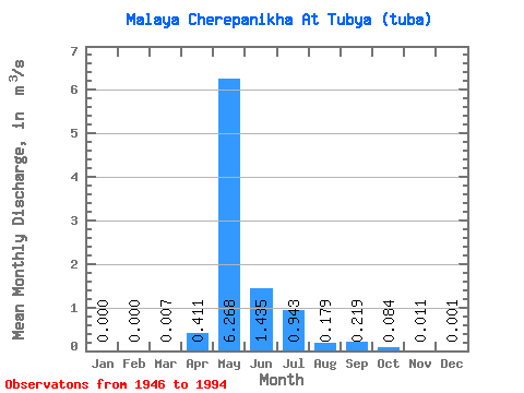
| Statistic | Jan | Feb | Mar | Apr | May | Jun | Jul | Aug | Sep | Oct | Nov | Dec | Annual |
|---|---|---|---|---|---|---|---|---|---|---|---|---|---|
| Mean | 0.00 | 0.00 | 0.01 | 0.41 | 6.27 | 1.44 | 0.94 | 0.18 | 0.22 | 0.08 | 0.01 | 0.00 | 0.80 |
| Standard Deviation | 0.00 | 0.00 | 0.04 | 0.92 | 4.17 | 1.34 | 3.10 | 0.33 | 0.35 | 0.09 | 0.03 | 0.00 | 0.56 |
| Min | 0.00 | 0.00 | 0.00 | 0.00 | 0.10 | 0.09 | 0.00 | 0.00 | 0.00 | 0.00 | 0.00 | 0.00 | 0.03 |
| Max | 0.00 | 0.00 | 0.29 | 4.13 | 16.00 | 5.62 | 19.90 | 1.84 | 1.67 | 0.31 | 0.13 | 0.02 | 3.24 |
| Coefficient of Variation | 6.40 | 2.23 | 0.67 | 0.93 | 3.29 | 1.84 | 1.59 | 1.10 | 2.36 | 4.32 | 0.71 |
 Return to R-Arctic Net Home Page