|
|
|||||||||||||||||
| Point ID: 7810 | Downloads | Plots | Site Data | Code: 3129 |
|
|
|||||||||||||||||
| Download | |
|---|---|
| Site Descriptor Information | Site Time Series Data |
| Link to all available data | |
| View: | Time Series | All |
| Units: | mm |
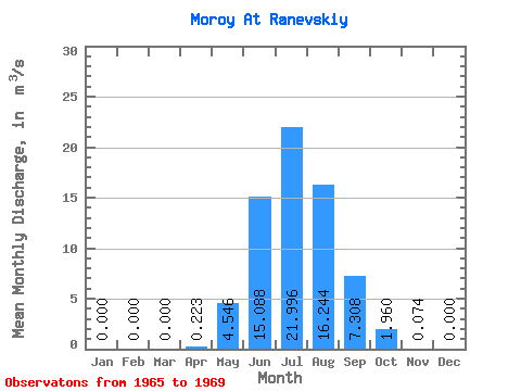
| Statistic | Jan | Feb | Mar | Apr | May | Jun | Jul | Aug | Sep | Oct | Nov | Dec | Annual |
|---|---|---|---|---|---|---|---|---|---|---|---|---|---|
| Mean | 0.00 | 0.00 | 0.00 | 0.22 | 4.55 | 15.09 | 22.00 | 16.24 | 7.31 | 1.96 | 0.07 | 0.00 | 5.62 |
| Standard Deviation | 0.00 | 0.00 | 0.00 | 0.29 | 2.76 | 11.51 | 23.26 | 9.11 | 2.83 | 1.43 | 0.04 | 0.00 | 2.83 |
| Min | 0.00 | 0.00 | 0.00 | 0.00 | 1.24 | 5.54 | 4.00 | 5.32 | 3.38 | 0.66 | 0.01 | 0.00 | 3.37 |
| Max | 0.00 | 0.00 | 0.00 | 0.69 | 8.01 | 32.80 | 50.20 | 29.70 | 10.20 | 3.66 | 0.12 | 0.00 | 9.27 |
| Coefficient of Variation | 1.32 | 0.61 | 0.76 | 1.06 | 0.56 | 0.39 | 0.73 | 0.56 | 0.50 |
 Return to R-Arctic Net Home Page