|
|
|||||||||||||||||
| Point ID: 7803 | Downloads | Plots | Site Data | Code: 3098 |
|
|
|||||||||||||||||
| Download | |
|---|---|
| Site Descriptor Information | Site Time Series Data |
| Link to all available data | |
| View: | Time Series | All |
| Units: | mm |
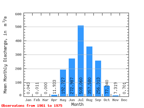
| Statistic | Jan | Feb | Mar | Apr | May | Jun | Jul | Aug | Sep | Oct | Nov | Dec | Annual |
|---|---|---|---|---|---|---|---|---|---|---|---|---|---|
| Mean | 0.04 | 0.01 | 0.00 | 11.93 | 192.73 | 272.99 | 508.06 | 357.58 | 256.31 | 77.34 | 7.32 | 0.70 | 140.42 |
| Standard Deviation | 0.13 | 0.04 | 0.00 | 16.33 | 144.01 | 213.97 | 476.68 | 422.90 | 241.27 | 45.46 | 6.03 | 0.64 | 79.63 |
| Min | 0.00 | 0.00 | 0.00 | 0.00 | 29.70 | 47.90 | 75.80 | 65.80 | 20.20 | 14.90 | 1.73 | 0.11 | 35.12 |
| Max | 0.50 | 0.16 | 0.00 | 52.20 | 451.00 | 809.00 | 1460.00 | 1240.00 | 942.00 | 150.00 | 25.20 | 2.26 | 284.32 |
| Coefficient of Variation | 3.01 | 3.87 | 1.37 | 0.75 | 0.78 | 0.94 | 1.18 | 0.94 | 0.59 | 0.82 | 0.91 | 0.57 |
 Return to R-Arctic Net Home Page