|
|
|||||||||||||||||
| Point ID: 7798 | Downloads | Plots | Site Data | Code: 3085 |
|
|
|||||||||||||||||
| Download | |
|---|---|
| Site Descriptor Information | Site Time Series Data |
| Link to all available data | |
| View: | Time Series | All |
| Units: | mm |
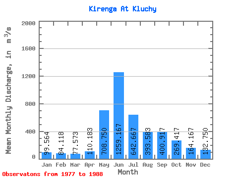
| Statistic | Jan | Feb | Mar | Apr | May | Jun | Jul | Aug | Sep | Oct | Nov | Dec | Annual |
|---|---|---|---|---|---|---|---|---|---|---|---|---|---|
| Mean | 99.56 | 84.12 | 77.57 | 110.18 | 708.75 | 1259.17 | 642.67 | 393.58 | 400.92 | 269.42 | 164.17 | 132.75 | 365.35 |
| Standard Deviation | 21.86 | 19.34 | 13.59 | 28.69 | 122.87 | 295.25 | 405.98 | 168.24 | 160.66 | 62.22 | 39.55 | 39.62 | 80.92 |
| Min | 68.70 | 57.60 | 56.00 | 74.00 | 499.00 | 559.00 | 282.00 | 197.00 | 204.00 | 185.00 | 113.00 | 73.30 | 275.38 |
| Max | 134.00 | 112.00 | 101.00 | 164.00 | 913.00 | 1570.00 | 1720.00 | 813.00 | 675.00 | 390.00 | 230.00 | 190.00 | 541.25 |
| Coefficient of Variation | 0.22 | 0.23 | 0.17 | 0.26 | 0.17 | 0.23 | 0.63 | 0.43 | 0.40 | 0.23 | 0.24 | 0.30 | 0.22 |
 Return to R-Arctic Net Home Page