|
|
|||||||||||||||||
| Point ID: 7790 | Downloads | Plots | Site Data | Code: 3061 |
|
|
|||||||||||||||||
| Download | |
|---|---|
| Site Descriptor Information | Site Time Series Data |
| Link to all available data | |
| View: | Time Series | All |
| Units: | mm |
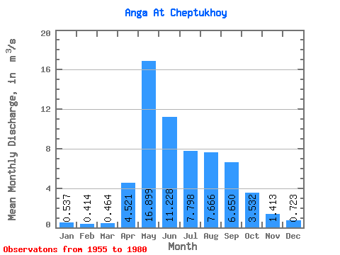
| Statistic | Jan | Feb | Mar | Apr | May | Jun | Jul | Aug | Sep | Oct | Nov | Dec | Annual |
|---|---|---|---|---|---|---|---|---|---|---|---|---|---|
| Mean | 0.54 | 0.41 | 0.46 | 4.52 | 16.90 | 11.23 | 7.80 | 7.67 | 6.65 | 3.53 | 1.41 | 0.72 | 5.23 |
| Standard Deviation | 0.51 | 0.40 | 0.41 | 5.34 | 8.62 | 6.85 | 4.94 | 6.36 | 4.79 | 2.07 | 0.95 | 0.68 | 2.45 |
| Min | 0.00 | 0.00 | 0.00 | 0.62 | 7.45 | 3.17 | 1.79 | 1.95 | 1.72 | 1.22 | 0.36 | 0.02 | 2.05 |
| Max | 1.48 | 1.16 | 0.99 | 17.90 | 29.60 | 25.00 | 20.10 | 22.60 | 15.20 | 8.09 | 3.28 | 2.13 | 9.06 |
| Coefficient of Variation | 0.96 | 0.97 | 0.88 | 1.18 | 0.51 | 0.61 | 0.63 | 0.83 | 0.72 | 0.59 | 0.67 | 0.94 | 0.47 |
 Return to R-Arctic Net Home Page