|
|
|||||||||||||||||
| Point ID: 779 | Downloads | Plots | Site Data | Code: 07HA005 |
|
|
|||||||||||||||||
| Download | |
|---|---|
| Site Descriptor Information | Site Time Series Data |
| Link to all available data | |
| View: | Time Series | All |
| Units: | mm |
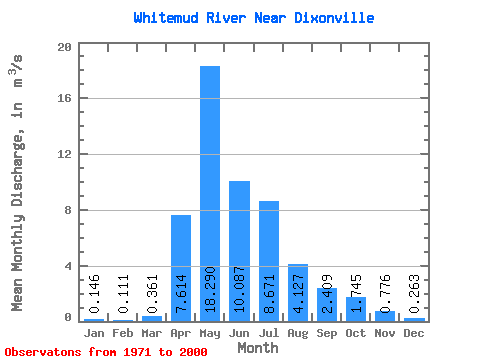
| Statistic | Jan | Feb | Mar | Apr | May | Jun | Jul | Aug | Sep | Oct | Nov | Dec | Annual |
|---|---|---|---|---|---|---|---|---|---|---|---|---|---|
| Mean | 0.15 | 0.11 | 0.36 | 7.61 | 18.29 | 10.09 | 8.67 | 4.13 | 2.41 | 1.75 | 0.78 | 0.26 | 5.04 |
| Standard Deviation | 0.11 | 0.09 | 0.82 | 6.70 | 16.08 | 10.00 | 8.45 | 4.57 | 3.49 | 1.62 | 0.52 | 0.17 | 2.72 |
| Min | 0.00 | 0.01 | 0.01 | 0.24 | 1.03 | 0.89 | 0.11 | 0.17 | 0.03 | 0.09 | 0.16 | 0.07 | 1.12 |
| Max | 0.35 | 0.34 | 4.47 | 32.10 | 66.40 | 43.30 | 29.10 | 17.40 | 18.70 | 5.74 | 1.81 | 0.55 | 11.19 |
| Coefficient of Variation | 0.74 | 0.77 | 2.27 | 0.88 | 0.88 | 0.99 | 0.97 | 1.11 | 1.45 | 0.93 | 0.67 | 0.64 | 0.54 |
 Return to R-Arctic Net Home Page