|
|
|||||||||||||||||
| Point ID: 7786 | Downloads | Plots | Site Data | Code: 3014 |
|
|
|||||||||||||||||
| Download | |
|---|---|
| Site Descriptor Information | Site Time Series Data |
| Link to all available data | |
| View: | Time Series | All |
| Units: | mm |
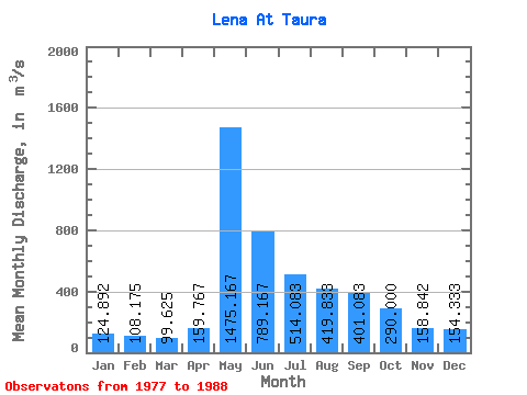
| Statistic | Jan | Feb | Mar | Apr | May | Jun | Jul | Aug | Sep | Oct | Nov | Dec | Annual |
|---|---|---|---|---|---|---|---|---|---|---|---|---|---|
| Mean | 124.89 | 108.17 | 99.62 | 159.77 | 1475.17 | 789.17 | 514.08 | 419.83 | 401.08 | 290.00 | 158.84 | 154.33 | 391.25 |
| Standard Deviation | 40.34 | 32.81 | 28.12 | 91.18 | 308.29 | 263.08 | 261.74 | 207.50 | 164.32 | 108.84 | 59.11 | 46.60 | 88.36 |
| Min | 82.00 | 67.50 | 68.00 | 82.20 | 922.00 | 308.00 | 221.00 | 212.00 | 201.00 | 154.00 | 92.10 | 102.00 | 308.40 |
| Max | 209.00 | 177.00 | 158.00 | 421.00 | 1900.00 | 1370.00 | 995.00 | 819.00 | 724.00 | 522.00 | 301.00 | 254.00 | 595.83 |
| Coefficient of Variation | 0.32 | 0.30 | 0.28 | 0.57 | 0.21 | 0.33 | 0.51 | 0.49 | 0.41 | 0.38 | 0.37 | 0.30 | 0.23 |
 Return to R-Arctic Net Home Page