|
|
|||||||||||||||||
| Point ID: 7785 | Downloads | Plots | Site Data | Code: 3009 |
|
|
|||||||||||||||||
| Download | |
|---|---|
| Site Descriptor Information | Site Time Series Data |
| Link to all available data | |
| View: | Time Series | All |
| Units: | mm |
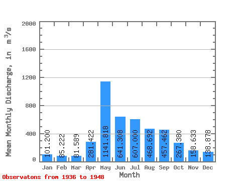
| Statistic | Jan | Feb | Mar | Apr | May | Jun | Jul | Aug | Sep | Oct | Nov | Dec | Annual |
|---|---|---|---|---|---|---|---|---|---|---|---|---|---|
| Mean | 101.20 | 85.22 | 81.59 | 281.42 | 1141.82 | 641.31 | 607.00 | 468.69 | 457.46 | 267.38 | 158.63 | 138.88 | 356.93 |
| Standard Deviation | 37.64 | 32.86 | 33.89 | 231.32 | 355.43 | 360.34 | 359.37 | 252.89 | 224.96 | 104.20 | 65.03 | 53.45 | 97.30 |
| Min | 45.80 | 39.70 | 37.80 | 79.60 | 594.00 | 211.00 | 129.00 | 97.00 | 103.00 | 85.80 | 56.00 | 50.50 | 164.33 |
| Max | 171.00 | 149.00 | 149.00 | 693.00 | 1790.00 | 1250.00 | 1480.00 | 1140.00 | 1010.00 | 383.00 | 242.00 | 215.00 | 499.83 |
| Coefficient of Variation | 0.37 | 0.39 | 0.41 | 0.82 | 0.31 | 0.56 | 0.59 | 0.54 | 0.49 | 0.39 | 0.41 | 0.39 | 0.27 |
 Return to R-Arctic Net Home Page