|
|
|||||||||||||||||
| Point ID: 7784 | Downloads | Plots | Site Data | Code: 3008 |
|
|
|||||||||||||||||
| Download | |
|---|---|
| Site Descriptor Information | Site Time Series Data |
| Link to all available data | |
| View: | Time Series | All |
| Units: | mm |
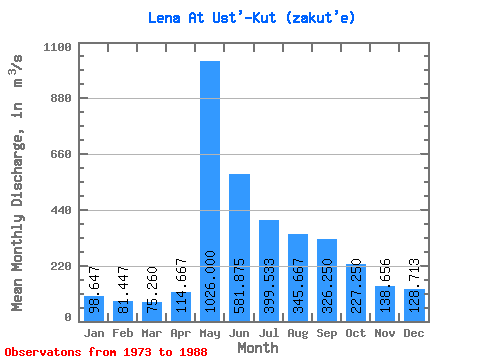
| Statistic | Jan | Feb | Mar | Apr | May | Jun | Jul | Aug | Sep | Oct | Nov | Dec | Annual |
|---|---|---|---|---|---|---|---|---|---|---|---|---|---|
| Mean | 98.65 | 81.45 | 75.26 | 114.67 | 1026.00 | 581.88 | 399.53 | 345.67 | 326.25 | 227.25 | 138.66 | 128.71 | 295.15 |
| Standard Deviation | 33.76 | 29.47 | 26.41 | 44.44 | 224.10 | 182.17 | 209.29 | 167.66 | 136.46 | 87.31 | 50.47 | 40.88 | 68.66 |
| Min | 58.10 | 46.50 | 51.80 | 61.70 | 608.00 | 220.00 | 175.00 | 140.00 | 153.00 | 113.00 | 70.70 | 82.60 | 207.74 |
| Max | 174.00 | 160.00 | 153.00 | 221.00 | 1320.00 | 941.00 | 813.00 | 622.00 | 654.00 | 470.00 | 287.00 | 239.00 | 473.37 |
| Coefficient of Variation | 0.34 | 0.36 | 0.35 | 0.39 | 0.22 | 0.31 | 0.52 | 0.48 | 0.42 | 0.38 | 0.36 | 0.32 | 0.23 |
 Return to R-Arctic Net Home Page