|
|
|||||||||||||||||
| Point ID: 7763 | Downloads | Plots | Site Data | Code: 07GB003 |
|
|
|||||||||||||||||
| Download | |
|---|---|
| Site Descriptor Information | Site Time Series Data |
| Link to all available data | |
| View: | Time Series | All |
| Units: | mm |
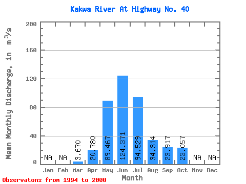
| Statistic | Jan | Feb | Mar | Apr | May | Jun | Jul | Aug | Sep | Oct | Nov | Dec | Annual |
|---|---|---|---|---|---|---|---|---|---|---|---|---|---|
| Mean | 3.67 | 20.78 | 89.47 | 124.37 | 94.53 | 34.31 | 23.92 | 23.06 | |||||
| Standard Deviation | 0.86 | 12.74 | 21.43 | 38.95 | 46.94 | 12.86 | 17.57 | 12.41 | |||||
| Min | 2.66 | 7.08 | 48.00 | 58.60 | 48.20 | 15.20 | 7.92 | 13.30 | |||||
| Max | 5.07 | 41.00 | 103.00 | 182.00 | 182.00 | 52.20 | 61.50 | 43.80 | |||||
| Coefficient of Variation | 0.23 | 0.61 | 0.24 | 0.31 | 0.50 | 0.38 | 0.73 | 0.54 |
 Return to R-Arctic Net Home Page