|
|
|||||||||||||||||
| Point ID: 7753 | Downloads | Plots | Site Data | Code: 05EE930 |
|
|
|||||||||||||||||
| Download | |
|---|---|
| Site Descriptor Information | Site Time Series Data |
| Link to all available data | |
| View: | Time Series | All |
| Units: | mm |
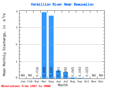
| Statistic | Jan | Feb | Mar | Apr | May | Jun | Jul | Aug | Sep | Oct | Nov | Dec | Annual |
|---|---|---|---|---|---|---|---|---|---|---|---|---|---|
| Mean | 0.02 | 3.89 | 3.69 | 0.46 | 0.39 | 0.07 | 0.04 | 0.02 | |||||
| Standard Deviation | 0.01 | 6.56 | 6.81 | 0.85 | 0.74 | 0.10 | 0.06 | 0.02 | |||||
| Min | 0.01 | 0.04 | 0.01 | 0.01 | 0.01 | 0.01 | 0.01 | 0.00 | |||||
| Max | 0.02 | 13.70 | 13.90 | 1.74 | 1.50 | 0.21 | 0.14 | 0.06 | |||||
| Coefficient of Variation | 0.44 | 1.69 | 1.85 | 1.85 | 1.89 | 1.53 | 1.47 | 1.05 |
 Return to R-Arctic Net Home Page