|
|
|||||||||||||||||
| Point ID: 7747 | Downloads | Plots | Site Data | Code: 04GA001 |
|
|
|||||||||||||||||
| Download | |
|---|---|
| Site Descriptor Information | Site Time Series Data |
| Link to all available data | |
| View: | Time Series | All |
| Units: | mm |
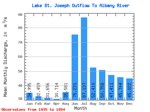
| Statistic | Jan | Feb | Mar | Apr | May | Jun | Jul | Aug | Sep | Oct | Nov | Dec | Annual |
|---|---|---|---|---|---|---|---|---|---|---|---|---|---|
| Mean | 34.99 | 32.46 | 31.66 | 30.71 | 35.58 | 75.23 | 87.14 | 52.41 | 50.76 | 47.41 | 45.74 | 45.02 | 46.77 |
| Standard Deviation | 39.59 | 36.03 | 36.96 | 39.42 | 55.91 | 113.15 | 113.10 | 63.10 | 68.87 | 74.40 | 64.39 | 57.17 | 44.70 |
| Min | 0.00 | 0.00 | 0.00 | 0.00 | 0.00 | 0.00 | 0.00 | 0.00 | 0.00 | 0.00 | 0.00 | 0.00 | 0.00 |
| Max | 128.00 | 110.00 | 112.00 | 130.00 | 251.00 | 433.00 | 387.00 | 245.00 | 284.00 | 300.00 | 267.00 | 244.00 | 151.18 |
| Coefficient of Variation | 1.13 | 1.11 | 1.17 | 1.28 | 1.57 | 1.50 | 1.30 | 1.20 | 1.36 | 1.57 | 1.41 | 1.27 | 0.96 |
 Return to R-Arctic Net Home Page