|
|
|||||||||||||||||
| Point ID: 774 | Downloads | Plots | Site Data | Code: 07GJ004 |
|
|
|||||||||||||||||
| Download | |
|---|---|
| Site Descriptor Information | Site Time Series Data |
| Link to all available data | |
| View: | Time Series | All |
| Units: | mm |
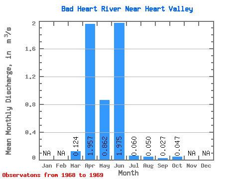
| Statistic | Jan | Feb | Mar | Apr | May | Jun | Jul | Aug | Sep | Oct | Nov | Dec | Annual |
|---|---|---|---|---|---|---|---|---|---|---|---|---|---|
| Mean | 0.12 | 1.96 | 0.86 | 1.98 | 0.06 | 0.05 | 0.03 | 0.05 | |||||
| Standard Deviation | 0.17 | 2.27 | 0.39 | 2.71 | 0.00 | ||||||||
| Min | 0.00 | 0.35 | 0.58 | 0.06 | 0.06 | 0.05 | 0.03 | 0.05 | |||||
| Max | 0.25 | 3.56 | 1.14 | 3.89 | 0.06 | 0.05 | 0.03 | 0.05 | |||||
| Coefficient of Variation | 1.41 | 1.16 | 0.46 | 1.37 | 0.02 |
 Return to R-Arctic Net Home Page