|
|
|||||||||||||||||
| Point ID: 7727 | Downloads | Plots | Site Data | Code: NO011 |
|
|
|||||||||||||||||
| Download | |
|---|---|
| Site Descriptor Information | Site Time Series Data |
| Link to all available data | |
| View: | Time Series | All |
| Units: | mm |
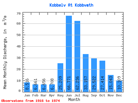
| Statistic | Jan | Feb | Mar | Apr | May | Jun | Jul | Aug | Sep | Oct | Nov | Dec | Annual |
|---|---|---|---|---|---|---|---|---|---|---|---|---|---|
| Mean | 8.52 | 6.66 | 6.66 | 6.71 | 25.21 | 66.77 | 62.24 | 33.16 | 29.52 | 27.41 | 15.04 | 10.11 | 24.84 |
| Standard Deviation | 7.07 | 5.41 | 5.03 | 3.31 | 11.24 | 16.59 | 18.52 | 11.30 | 11.59 | 14.27 | 9.78 | 7.28 | 4.67 |
| Min | 0.93 | 0.79 | 1.10 | 0.55 | 1.00 | 26.45 | 26.31 | 15.50 | 11.63 | 6.08 | 3.40 | 1.89 | 14.11 |
| Max | 38.68 | 31.69 | 24.52 | 16.03 | 62.36 | 120.19 | 99.06 | 61.70 | 62.01 | 70.55 | 45.36 | 39.38 | 37.58 |
| Coefficient of Variation | 0.83 | 0.81 | 0.76 | 0.49 | 0.45 | 0.25 | 0.30 | 0.34 | 0.39 | 0.52 | 0.65 | 0.72 | 0.19 |
 Return to R-Arctic Net Home Page