|
|
|||||||||||||||||
| Point ID: 7726 | Downloads | Plots | Site Data | Code: NO007 |
|
|
|||||||||||||||||
| Download | |
|---|---|
| Site Descriptor Information | Site Time Series Data |
| Link to all available data | |
| View: | Time Series | All |
| Units: | mm |
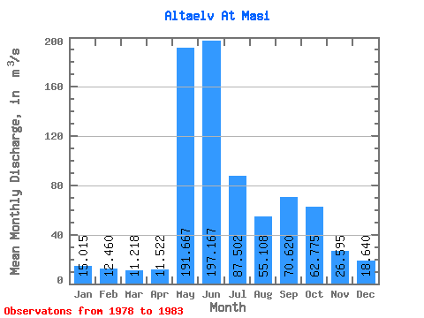
| Statistic | Jan | Feb | Mar | Apr | May | Jun | Jul | Aug | Sep | Oct | Nov | Dec | Annual |
|---|---|---|---|---|---|---|---|---|---|---|---|---|---|
| Mean | 15.02 | 12.46 | 11.22 | 11.52 | 191.67 | 197.17 | 87.50 | 55.11 | 70.62 | 62.77 | 26.59 | 18.64 | 63.36 |
| Standard Deviation | 1.93 | 2.06 | 2.12 | 3.72 | 48.02 | 53.94 | 64.36 | 36.21 | 47.67 | 40.37 | 3.03 | 2.69 | 14.47 |
| Min | 12.03 | 10.39 | 8.98 | 8.17 | 137.00 | 130.00 | 36.04 | 21.67 | 22.98 | 25.90 | 21.66 | 14.65 | 46.69 |
| Max | 17.76 | 16.20 | 14.99 | 18.76 | 268.00 | 251.00 | 198.00 | 113.00 | 158.00 | 140.00 | 30.41 | 22.16 | 82.21 |
| Coefficient of Variation | 0.13 | 0.17 | 0.19 | 0.32 | 0.25 | 0.27 | 0.74 | 0.66 | 0.68 | 0.64 | 0.11 | 0.14 | 0.23 |
 Return to R-Arctic Net Home Page