|
|
|||||||||||||||||
| Point ID: 771 | Downloads | Plots | Site Data | Code: 07GH005 |
|
|
|||||||||||||||||
| Download | |
|---|---|
| Site Descriptor Information | Site Time Series Data |
| Link to all available data | |
| View: | Time Series | All |
| Units: | mm |
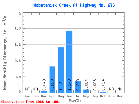
| Statistic | Jan | Feb | Mar | Apr | May | Jun | Jul | Aug | Sep | Oct | Nov | Dec | Annual |
|---|---|---|---|---|---|---|---|---|---|---|---|---|---|
| Mean | 0.04 | 0.66 | 1.13 | 1.54 | 0.30 | 0.08 | 0.01 | 0.02 | |||||
| Standard Deviation | 0.04 | 0.52 | 1.16 | 2.45 | 0.48 | 0.16 | 0.00 | 0.02 | |||||
| Min | 0.00 | 0.13 | 0.21 | 0.10 | 0.00 | 0.00 | 0.00 | 0.00 | |||||
| Max | 0.08 | 1.61 | 2.98 | 5.85 | 1.14 | 0.37 | 0.01 | 0.06 | |||||
| Coefficient of Variation | 0.92 | 0.79 | 1.02 | 1.59 | 1.63 | 1.88 | 0.51 | 1.01 |
 Return to R-Arctic Net Home Page