|
|
|||||||||||||||||
| Point ID: 7706 | Downloads | Plots | Site Data | Code: 15564875 |
|
|
|||||||||||||||||
| Download | |
|---|---|
| Site Descriptor Information | Site Time Series Data |
| Link to all available data | |
| View: | Time Series | All |
| Units: | mm |
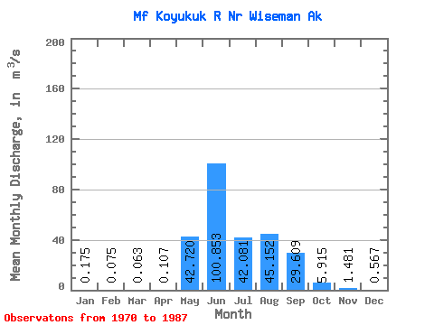
| Statistic | Jan | Feb | Mar | Apr | May | Jun | Jul | Aug | Sep | Oct | Nov | Dec | Annual |
|---|---|---|---|---|---|---|---|---|---|---|---|---|---|
| Mean | 0.17 | 0.07 | 0.06 | 0.11 | 42.72 | 100.85 | 42.08 | 45.15 | 29.61 | 5.92 | 1.48 | 0.57 | 21.58 |
| Standard Deviation | 0.20 | 0.13 | 0.12 | 0.17 | 23.29 | 33.58 | 16.09 | 27.65 | 18.97 | 3.48 | 1.08 | 0.60 | 6.65 |
| Min | 0.00 | 0.00 | 0.00 | 0.00 | 1.87 | 29.53 | 18.92 | 14.70 | 9.91 | 1.56 | 0.03 | 0.00 | 10.55 |
| Max | 0.70 | 0.48 | 0.42 | 0.62 | 73.57 | 145.29 | 69.80 | 99.11 | 78.69 | 14.41 | 3.37 | 2.07 | 30.92 |
| Coefficient of Variation | 1.15 | 1.77 | 1.88 | 1.59 | 0.55 | 0.33 | 0.38 | 0.61 | 0.64 | 0.59 | 0.73 | 1.06 | 0.31 |
 Return to R-Arctic Net Home Page