|
|
|||||||||||||||||
| Point ID: 7704 | Downloads | Plots | Site Data | Code: 15518000 |
|
|
|||||||||||||||||
| Download | |
|---|---|
| Site Descriptor Information | Site Time Series Data |
| Link to all available data | |
| View: | Time Series | All |
| Units: | mm |
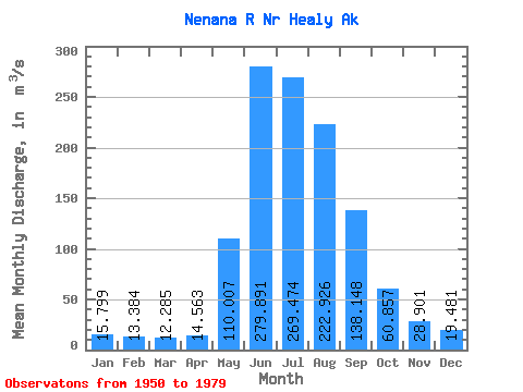
| Statistic | Jan | Feb | Mar | Apr | May | Jun | Jul | Aug | Sep | Oct | Nov | Dec | Annual |
|---|---|---|---|---|---|---|---|---|---|---|---|---|---|
| Mean | 15.80 | 13.38 | 12.29 | 14.56 | 110.01 | 279.89 | 269.47 | 222.93 | 138.15 | 60.86 | 28.90 | 19.48 | 99.15 |
| Standard Deviation | 3.38 | 2.64 | 2.42 | 2.95 | 33.74 | 76.09 | 60.38 | 56.26 | 41.45 | 16.24 | 9.21 | 5.33 | 16.08 |
| Min | 6.46 | 5.38 | 5.38 | 5.72 | 26.02 | 155.18 | 166.25 | 121.96 | 59.72 | 29.28 | 11.44 | 7.42 | 64.22 |
| Max | 21.83 | 17.70 | 16.96 | 22.82 | 182.42 | 426.45 | 434.38 | 370.67 | 239.59 | 99.42 | 49.98 | 39.27 | 128.50 |
| Coefficient of Variation | 0.21 | 0.20 | 0.20 | 0.20 | 0.31 | 0.27 | 0.22 | 0.25 | 0.30 | 0.27 | 0.32 | 0.27 | 0.16 |
 Return to R-Arctic Net Home Page