|
|
|||||||||||||||||
| Point ID: 7675 | Downloads | Plots | Site Data | Code: 7202 |
|
|
|||||||||||||||||
| Download | |
|---|---|
| Site Descriptor Information | Site Time Series Data |
| Link to all available data | |
| View: | Time Series | All |
| Units: | mm |
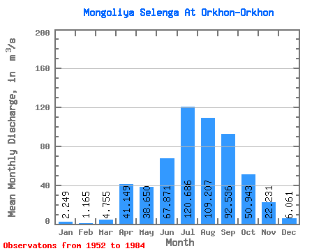
| Statistic | Jan | Feb | Mar | Apr | May | Jun | Jul | Aug | Sep | Oct | Nov | Dec | Annual |
|---|---|---|---|---|---|---|---|---|---|---|---|---|---|
| Mean | 2.25 | 1.17 | 4.75 | 41.15 | 38.65 | 67.87 | 120.69 | 109.21 | 92.54 | 50.94 | 22.23 | 6.06 | 46.46 |
| Standard Deviation | 2.39 | 1.09 | 4.62 | 32.06 | 17.04 | 55.82 | 87.35 | 56.77 | 54.23 | 23.86 | 11.62 | 4.31 | 23.97 |
| Min | 0.07 | 0.00 | 0.01 | 6.28 | 16.60 | 22.60 | 18.00 | 23.50 | 31.00 | 25.00 | 9.64 | 1.26 | 17.21 |
| Max | 8.90 | 2.70 | 15.00 | 129.00 | 72.50 | 202.00 | 304.00 | 219.00 | 195.00 | 97.70 | 51.00 | 18.00 | 96.80 |
| Coefficient of Variation | 1.06 | 0.93 | 0.97 | 0.78 | 0.44 | 0.82 | 0.72 | 0.52 | 0.59 | 0.47 | 0.52 | 0.71 | 0.52 |
 Return to R-Arctic Net Home Page