|
|
|||||||||||||||||
| Point ID: 765 | Downloads | Plots | Site Data | Code: 07GG001 |
|
|
|||||||||||||||||
| Download | |
|---|---|
| Site Descriptor Information | Site Time Series Data |
| Link to all available data | |
| View: | Time Series | All |
| Units: | mm |
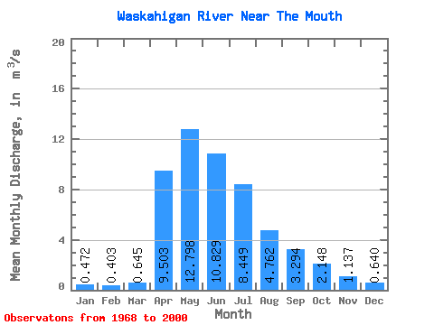
| Statistic | Jan | Feb | Mar | Apr | May | Jun | Jul | Aug | Sep | Oct | Nov | Dec | Annual |
|---|---|---|---|---|---|---|---|---|---|---|---|---|---|
| Mean | 0.47 | 0.40 | 0.65 | 9.50 | 12.80 | 10.83 | 8.45 | 4.76 | 3.29 | 2.15 | 1.14 | 0.64 | 4.77 |
| Standard Deviation | 0.18 | 0.15 | 0.83 | 6.27 | 8.01 | 8.91 | 8.73 | 5.36 | 3.55 | 1.68 | 0.76 | 0.41 | 1.90 |
| Min | 0.10 | 0.13 | 0.15 | 1.00 | 2.39 | 1.93 | 0.93 | 0.47 | 0.40 | 0.39 | 0.13 | 0.11 | 1.70 |
| Max | 0.89 | 0.75 | 5.12 | 28.00 | 29.10 | 35.60 | 35.90 | 21.00 | 15.40 | 6.65 | 4.09 | 2.15 | 8.36 |
| Coefficient of Variation | 0.39 | 0.37 | 1.29 | 0.66 | 0.63 | 0.82 | 1.03 | 1.12 | 1.08 | 0.78 | 0.67 | 0.64 | 0.40 |
 Return to R-Arctic Net Home Page