|
|
|||||||||||||||||
| Point ID: 7641 | Downloads | Plots | Site Data | Code: 71192 |
|
|
|||||||||||||||||
| Download | |
|---|---|
| Site Descriptor Information | Site Time Series Data |
| Link to all available data | |
| View: | Time Series | All |
| Units: | mm |
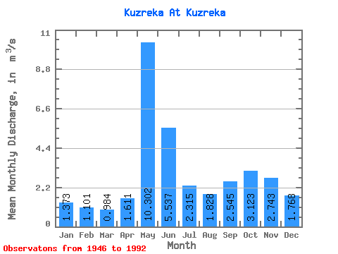
| Statistic | Jan | Feb | Mar | Apr | May | Jun | Jul | Aug | Sep | Oct | Nov | Dec | Annual |
|---|---|---|---|---|---|---|---|---|---|---|---|---|---|
| Mean | 1.37 | 1.10 | 0.98 | 1.61 | 10.30 | 5.54 | 2.31 | 1.83 | 2.54 | 3.12 | 2.74 | 1.77 | 2.95 |
| Standard Deviation | 0.49 | 0.37 | 0.28 | 0.94 | 3.50 | 3.00 | 1.21 | 1.04 | 1.19 | 1.38 | 1.61 | 0.88 | 0.63 |
| Min | 0.66 | 0.45 | 0.42 | 0.45 | 4.33 | 1.49 | 0.85 | 0.49 | 0.60 | 0.65 | 0.51 | 0.61 | 1.46 |
| Max | 2.91 | 2.46 | 1.84 | 4.58 | 19.40 | 15.60 | 5.43 | 5.48 | 4.53 | 6.02 | 6.82 | 5.72 | 4.58 |
| Coefficient of Variation | 0.36 | 0.34 | 0.28 | 0.58 | 0.34 | 0.54 | 0.52 | 0.57 | 0.47 | 0.44 | 0.59 | 0.50 | 0.21 |
 Return to R-Arctic Net Home Page