|
|
|||||||||||||||||
| Point ID: 7620 | Downloads | Plots | Site Data | Code: 71156 |
|
|
|||||||||||||||||
| Download | |
|---|---|
| Site Descriptor Information | Site Time Series Data |
| Link to all available data | |
| View: | Time Series | All |
| Units: | mm |
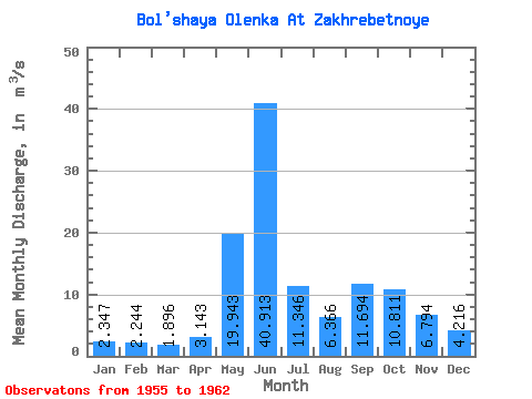
| Statistic | Jan | Feb | Mar | Apr | May | Jun | Jul | Aug | Sep | Oct | Nov | Dec | Annual |
|---|---|---|---|---|---|---|---|---|---|---|---|---|---|
| Mean | 2.35 | 2.24 | 1.90 | 3.14 | 19.94 | 40.91 | 11.35 | 6.37 | 11.69 | 10.81 | 6.79 | 4.22 | 10.04 |
| Standard Deviation | 0.83 | 0.67 | 0.36 | 3.28 | 12.85 | 19.48 | 7.97 | 4.63 | 8.45 | 5.74 | 2.12 | 1.71 | 2.31 |
| Min | 1.42 | 1.19 | 1.33 | 1.02 | 2.73 | 11.50 | 2.11 | 0.69 | 4.27 | 4.89 | 3.59 | 1.61 | 6.42 |
| Max | 3.74 | 3.26 | 2.47 | 10.50 | 35.40 | 70.30 | 28.40 | 15.00 | 29.30 | 20.80 | 9.84 | 7.30 | 12.63 |
| Coefficient of Variation | 0.35 | 0.30 | 0.19 | 1.04 | 0.65 | 0.48 | 0.70 | 0.73 | 0.72 | 0.53 | 0.31 | 0.41 | 0.23 |
 Return to R-Arctic Net Home Page