|
|
|||||||||||||||||
| Point ID: 762 | Downloads | Plots | Site Data | Code: 07GF006 |
|
|
|||||||||||||||||
| Download | |
|---|---|
| Site Descriptor Information | Site Time Series Data |
| Link to all available data | |
| View: | Time Series | All |
| Units: | mm |
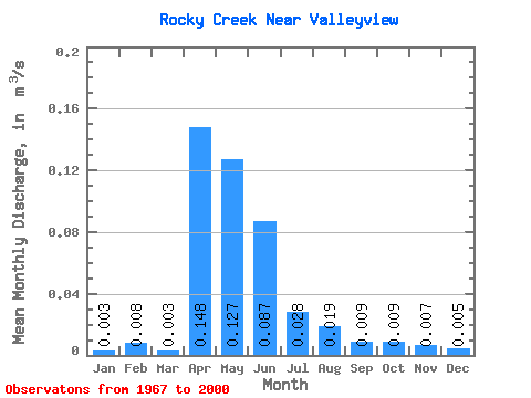
| Statistic | Jan | Feb | Mar | Apr | May | Jun | Jul | Aug | Sep | Oct | Nov | Dec | Annual |
|---|---|---|---|---|---|---|---|---|---|---|---|---|---|
| Mean | 0.00 | 0.01 | 0.00 | 0.15 | 0.13 | 0.09 | 0.03 | 0.02 | 0.01 | 0.01 | 0.01 | 0.01 | |
| Standard Deviation | 0.00 | 0.00 | 0.13 | 0.17 | 0.11 | 0.05 | 0.06 | 0.01 | 0.01 | 0.00 | 0.00 | ||
| Min | 0.00 | 0.01 | 0.00 | 0.01 | 0.00 | 0.00 | 0.00 | 0.00 | 0.00 | 0.00 | 0.01 | 0.00 | |
| Max | 0.01 | 0.01 | 0.01 | 0.46 | 0.84 | 0.40 | 0.18 | 0.28 | 0.06 | 0.05 | 0.01 | 0.01 | |
| Coefficient of Variation | 0.61 | 0.90 | 0.87 | 1.37 | 1.28 | 1.61 | 2.96 | 1.49 | 1.47 | 0.47 | 0.12 |
 Return to R-Arctic Net Home Page