|
|
|||||||||||||||||
| Point ID: 7607 | Downloads | Plots | Site Data | Code: 71130 |
|
|
|||||||||||||||||
| Download | |
|---|---|
| Site Descriptor Information | Site Time Series Data |
| Link to all available data | |
| View: | Time Series | All |
| Units: | mm |
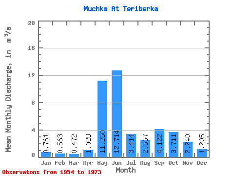
| Statistic | Jan | Feb | Mar | Apr | May | Jun | Jul | Aug | Sep | Oct | Nov | Dec | Annual |
|---|---|---|---|---|---|---|---|---|---|---|---|---|---|
| Mean | 0.76 | 0.56 | 0.47 | 1.03 | 11.25 | 12.71 | 3.41 | 2.57 | 4.12 | 3.71 | 2.24 | 1.21 | 3.75 |
| Standard Deviation | 0.19 | 0.13 | 0.12 | 1.44 | 6.01 | 8.27 | 1.56 | 1.47 | 2.62 | 1.47 | 0.68 | 0.41 | 0.71 |
| Min | 0.42 | 0.32 | 0.30 | 0.30 | 1.01 | 2.46 | 0.61 | 0.50 | 1.56 | 1.53 | 1.22 | 0.66 | 2.07 |
| Max | 1.02 | 0.79 | 0.72 | 5.04 | 22.20 | 31.10 | 6.82 | 5.48 | 10.80 | 6.02 | 3.36 | 1.96 | 4.61 |
| Coefficient of Variation | 0.25 | 0.24 | 0.26 | 1.40 | 0.53 | 0.65 | 0.46 | 0.57 | 0.64 | 0.40 | 0.30 | 0.34 | 0.19 |
 Return to R-Arctic Net Home Page