|
|
|||||||||||||||||
| Point ID: 7599 | Downloads | Plots | Site Data | Code: 71098 |
|
|
|||||||||||||||||
| Download | |
|---|---|
| Site Descriptor Information | Site Time Series Data |
| Link to all available data | |
| View: | Time Series | All |
| Units: | mm |
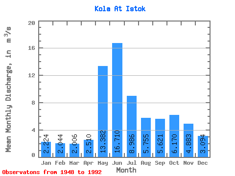
| Statistic | Jan | Feb | Mar | Apr | May | Jun | Jul | Aug | Sep | Oct | Nov | Dec | Annual |
|---|---|---|---|---|---|---|---|---|---|---|---|---|---|
| Mean | 2.22 | 2.04 | 2.01 | 2.51 | 13.38 | 16.71 | 8.99 | 5.75 | 5.62 | 6.17 | 4.88 | 3.09 | 6.23 |
| Standard Deviation | 0.90 | 0.81 | 0.73 | 0.86 | 5.91 | 4.85 | 3.91 | 2.90 | 3.03 | 2.59 | 1.87 | 1.38 | 1.34 |
| Min | 0.05 | 0.06 | 0.00 | 1.05 | 3.94 | 7.66 | 3.53 | 1.46 | 1.41 | 1.34 | 0.92 | 0.35 | 4.05 |
| Max | 3.85 | 3.92 | 3.68 | 4.98 | 29.30 | 26.40 | 22.10 | 14.60 | 17.70 | 11.60 | 10.20 | 6.58 | 10.19 |
| Coefficient of Variation | 0.41 | 0.40 | 0.36 | 0.34 | 0.44 | 0.29 | 0.43 | 0.50 | 0.54 | 0.42 | 0.38 | 0.45 | 0.21 |
 Return to R-Arctic Net Home Page