|
|
|||||||||||||||||
| Point ID: 7582 | Downloads | Plots | Site Data | Code: 71055 |
|
|
|||||||||||||||||
| Download | |
|---|---|
| Site Descriptor Information | Site Time Series Data |
| Link to all available data | |
| View: | Time Series | All |
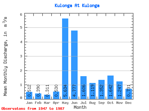
| Units: | mm |
| Statistic | Jan | Feb | Mar | Apr | May | Jun | Jul | Aug | Sep | Oct | Nov | Dec | Annual |
|---|---|---|---|---|---|---|---|---|---|---|---|---|---|
| Mean | 0.51 | 0.39 | 0.31 | 0.53 | 5.63 | 4.78 | 1.61 | 1.12 | 1.35 | 1.64 | 1.25 | 0.73 | 1.66 |
| Standard Deviation | 0.16 | 0.12 | 0.10 | 0.41 | 2.40 | 2.45 | 0.87 | 0.66 | 0.83 | 0.69 | 0.57 | 0.20 | 0.35 |
| Min | 0.18 | 0.15 | 0.14 | 0.14 | 1.20 | 1.23 | 0.44 | 0.14 | 0.41 | 0.49 | 0.43 | 0.36 | 0.87 |
| Max | 0.85 | 0.72 | 0.51 | 2.22 | 10.40 | 11.00 | 3.92 | 3.01 | 4.94 | 3.62 | 3.34 | 1.17 | 2.29 |
| Coefficient of Variation | 0.31 | 0.31 | 0.33 | 0.77 | 0.43 | 0.51 | 0.54 | 0.59 | 0.62 | 0.42 | 0.46 | 0.28 | 0.21 |
 Return to R-Arctic Net Home Page