|
|
|||||||||||||||||
| Point ID: 7564 | Downloads | Plots | Site Data | Code: 70801 |
|
|
|||||||||||||||||
| Download | |
|---|---|
| Site Descriptor Information | Site Time Series Data |
| Link to all available data | |
| View: | Time Series | All |
| Units: | mm |
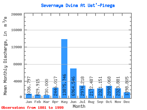
| Statistic | Jan | Feb | Mar | Apr | May | Jun | Jul | Aug | Sep | Oct | Nov | Dec | Annual |
|---|---|---|---|---|---|---|---|---|---|---|---|---|---|
| Mean | 1036.80 | 829.91 | 730.00 | 2446.02 | 13875.75 | 6964.55 | 2974.22 | 2172.49 | 2321.15 | 2898.07 | 2323.88 | 1398.81 | 3331.43 |
| Standard Deviation | 313.64 | 244.46 | 184.15 | 2233.79 | 3283.25 | 2856.69 | 1084.98 | 1053.40 | 1206.97 | 1387.17 | 1383.70 | 578.95 | 630.00 |
| Min | 369.00 | 319.00 | 348.00 | 488.00 | 5830.00 | 2300.00 | 1180.00 | 546.00 | 790.00 | 918.00 | 566.00 | 491.00 | 1785.00 |
| Max | 1910.00 | 1990.00 | 1280.00 | 10950.00 | 20800.00 | 16100.00 | 5990.00 | 6510.00 | 7580.00 | 8510.00 | 9750.00 | 3900.00 | 5245.08 |
| Coefficient of Variation | 0.30 | 0.29 | 0.25 | 0.91 | 0.24 | 0.41 | 0.36 | 0.48 | 0.52 | 0.48 | 0.59 | 0.41 | 0.19 |
 Return to R-Arctic Net Home Page