|
|
|||||||||||||||||
| Point ID: 7557 | Downloads | Plots | Site Data | Code: 70596 |
|
|
|||||||||||||||||
| Download | |
|---|---|
| Site Descriptor Information | Site Time Series Data |
| Link to all available data | |
| View: | Time Series | All |
| Units: | mm |
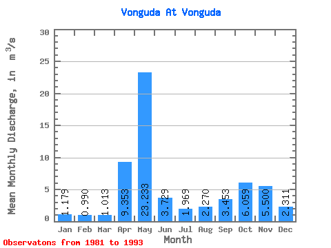
| Statistic | Jan | Feb | Mar | Apr | May | Jun | Jul | Aug | Sep | Oct | Nov | Dec | Annual |
|---|---|---|---|---|---|---|---|---|---|---|---|---|---|
| Mean | 1.18 | 0.99 | 1.01 | 9.35 | 23.23 | 3.73 | 1.97 | 2.27 | 3.45 | 6.06 | 5.50 | 2.31 | 5.06 |
| Standard Deviation | 0.54 | 0.36 | 0.48 | 9.58 | 7.75 | 1.76 | 0.91 | 1.30 | 1.33 | 3.64 | 3.59 | 1.70 | 0.92 |
| Min | 0.73 | 0.50 | 0.44 | 0.63 | 13.50 | 1.55 | 0.82 | 0.59 | 0.80 | 1.89 | 1.19 | 0.90 | 3.50 |
| Max | 2.32 | 1.65 | 1.99 | 27.70 | 36.70 | 6.63 | 4.33 | 4.62 | 6.11 | 15.20 | 11.40 | 5.80 | 7.02 |
| Coefficient of Variation | 0.46 | 0.37 | 0.47 | 1.02 | 0.33 | 0.47 | 0.46 | 0.57 | 0.39 | 0.60 | 0.65 | 0.74 | 0.18 |
 Return to R-Arctic Net Home Page