|
|
|||||||||||||||||
| Point ID: 7524 | Downloads | Plots | Site Data | Code: 70540 |
|
|
|||||||||||||||||
| Download | |
|---|---|
| Site Descriptor Information | Site Time Series Data |
| Link to all available data | |
| View: | Time Series | All |
| Units: | mm |
| Statistic | Jan | Feb | Mar | Apr | May | Jun | Jul | Aug | Sep | Oct | Nov | Dec | Annual |
|---|---|---|---|---|---|---|---|---|---|---|---|---|---|
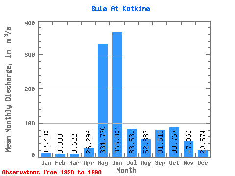
| Mean | 12.48 | 9.38 | 8.62 | 26.30 | 331.77 | 365.80 | 83.53 | 52.88 | 81.51 | 88.77 | 47.37 | 20.57 | 94.25 |
| Standard Deviation | 4.25 | 3.19 | 2.79 | 43.72 | 174.95 | 201.51 | 40.04 | 31.66 | 36.72 | 41.42 | 27.48 | 7.79 | 16.51 |
| Min | 6.83 | 4.73 | 3.30 | 3.72 | 7.98 | 97.40 | 33.80 | 18.20 | 19.40 | 19.40 | 13.70 | 7.56 | 55.55 |
| Max | 25.90 | 20.40 | 17.00 | 231.00 | 720.00 | 935.00 | 228.00 | 152.00 | 175.00 | 221.00 | 156.00 | 41.20 | 138.59 |
| Coefficient of Variation | 0.34 | 0.34 | 0.32 | 1.66 | 0.53 | 0.55 | 0.48 | 0.60 | 0.45 | 0.47 | 0.58 | 0.38 | 0.17 |
 Return to R-Arctic Net Home Page