|
|
|||||||||||||||||
| Point ID: 7483 | Downloads | Plots | Site Data | Code: 70421 |
|
|
|||||||||||||||||
| Download | |
|---|---|
| Site Descriptor Information | Site Time Series Data |
| Link to all available data | |
| View: | Time Series | All |
| Units: | mm |
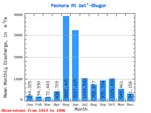
| Statistic | Jan | Feb | Mar | Apr | May | Jun | Jul | Aug | Sep | Oct | Nov | Dec | Annual |
|---|---|---|---|---|---|---|---|---|---|---|---|---|---|
| Mean | 244.32 | 194.59 | 172.44 | 436.71 | 3882.41 | 3237.62 | 1043.54 | 758.88 | 935.70 | 1026.82 | 549.46 | 341.16 | 1067.11 |
| Standard Deviation | 64.00 | 41.18 | 35.01 | 467.09 | 1034.68 | 1247.39 | 384.06 | 412.47 | 402.44 | 439.66 | 243.53 | 90.51 | 158.99 |
| Min | 143.00 | 118.00 | 102.00 | 150.00 | 1530.00 | 1170.00 | 416.00 | 314.00 | 264.00 | 220.00 | 258.00 | 202.00 | 635.75 |
| Max | 520.00 | 317.00 | 237.00 | 2300.00 | 5670.00 | 6740.00 | 2130.00 | 2230.00 | 2000.00 | 2370.00 | 1380.00 | 707.00 | 1560.33 |
| Coefficient of Variation | 0.26 | 0.21 | 0.20 | 1.07 | 0.27 | 0.39 | 0.37 | 0.54 | 0.43 | 0.43 | 0.44 | 0.27 | 0.15 |
 Return to R-Arctic Net Home Page