|
|
|||||||||||||||||
| Point ID: 7481 | Downloads | Plots | Site Data | Code: 70410 |
|
|
|||||||||||||||||
| Download | |
|---|---|
| Site Descriptor Information | Site Time Series Data |
| Link to all available data | |
| View: | Time Series | All |
| Units: | mm |
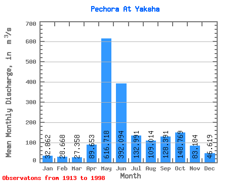
| Statistic | Jan | Feb | Mar | Apr | May | Jun | Jul | Aug | Sep | Oct | Nov | Dec | Annual |
|---|---|---|---|---|---|---|---|---|---|---|---|---|---|
| Mean | 32.86 | 28.67 | 27.36 | 89.65 | 616.72 | 392.09 | 132.99 | 109.01 | 128.39 | 148.77 | 83.18 | 46.62 | 152.97 |
| Standard Deviation | 7.26 | 5.92 | 4.63 | 95.22 | 165.01 | 190.17 | 59.23 | 66.94 | 58.51 | 61.77 | 35.20 | 10.49 | 23.01 |
| Min | 16.90 | 15.20 | 16.00 | 18.60 | 193.00 | 104.00 | 49.90 | 31.70 | 38.10 | 39.10 | 31.80 | 26.60 | 80.77 |
| Max | 64.10 | 58.50 | 47.20 | 474.00 | 1020.00 | 881.00 | 322.00 | 329.00 | 257.00 | 386.00 | 203.00 | 68.50 | 211.97 |
| Coefficient of Variation | 0.22 | 0.21 | 0.17 | 1.06 | 0.27 | 0.48 | 0.45 | 0.61 | 0.46 | 0.41 | 0.42 | 0.23 | 0.15 |
 Return to R-Arctic Net Home Page