|
|
|||||||||||||||||
| Point ID: 7465 | Downloads | Plots | Site Data | Code: 70376 |
|
|
|||||||||||||||||
| Download | |
|---|---|
| Site Descriptor Information | Site Time Series Data |
| Link to all available data | |
| View: | Time Series | All |
| Units: | mm |
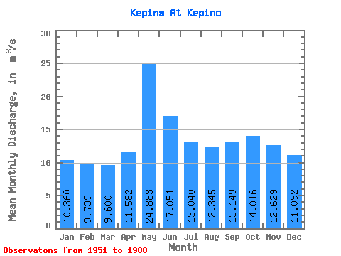
| Statistic | Jan | Feb | Mar | Apr | May | Jun | Jul | Aug | Sep | Oct | Nov | Dec | Annual |
|---|---|---|---|---|---|---|---|---|---|---|---|---|---|
| Mean | 10.36 | 9.74 | 9.60 | 11.58 | 24.88 | 17.05 | 13.04 | 12.35 | 13.15 | 14.02 | 12.63 | 11.09 | 13.26 |
| Standard Deviation | 1.47 | 1.60 | 1.49 | 3.58 | 6.38 | 6.05 | 2.50 | 2.98 | 2.94 | 3.23 | 2.46 | 1.89 | 1.94 |
| Min | 7.50 | 7.01 | 6.97 | 7.10 | 9.77 | 9.68 | 7.92 | 7.70 | 8.22 | 8.61 | 7.75 | 7.71 | 9.34 |
| Max | 13.40 | 12.70 | 12.10 | 20.80 | 39.70 | 34.80 | 21.20 | 21.40 | 20.80 | 21.70 | 19.80 | 15.00 | 16.66 |
| Coefficient of Variation | 0.14 | 0.17 | 0.15 | 0.31 | 0.26 | 0.35 | 0.19 | 0.24 | 0.22 | 0.23 | 0.19 | 0.17 | 0.15 |
 Return to R-Arctic Net Home Page