|
|
|||||||||||||||||
| Point ID: 746 | Downloads | Plots | Site Data | Code: 07GC002 |
|
|
|||||||||||||||||
| Download | |
|---|---|
| Site Descriptor Information | Site Time Series Data |
| Link to all available data | |
| View: | Time Series | All |
| Units: | mm |
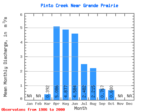
| Statistic | Jan | Feb | Mar | Apr | May | Jun | Jul | Aug | Sep | Oct | Nov | Dec | Annual |
|---|---|---|---|---|---|---|---|---|---|---|---|---|---|
| Mean | 0.39 | 5.09 | 4.88 | 4.58 | 2.48 | 2.21 | 0.77 | 0.68 | |||||
| Standard Deviation | 0.73 | 3.45 | 3.60 | 6.02 | 2.64 | 4.10 | 0.98 | 0.62 | |||||
| Min | 0.00 | 0.63 | 0.70 | 0.66 | 0.14 | 0.04 | 0.06 | 0.06 | |||||
| Max | 2.93 | 10.90 | 13.10 | 23.90 | 8.65 | 14.10 | 3.64 | 1.74 | |||||
| Coefficient of Variation | 1.87 | 0.68 | 0.74 | 1.31 | 1.06 | 1.85 | 1.27 | 0.91 |
 Return to R-Arctic Net Home Page