|
|
|||||||||||||||||
| Point ID: 7442 | Downloads | Plots | Site Data | Code: 70331 |
|
|
|||||||||||||||||
| Download | |
|---|---|
| Site Descriptor Information | Site Time Series Data |
| Link to all available data | |
| View: | Time Series | All |
| Units: | mm |
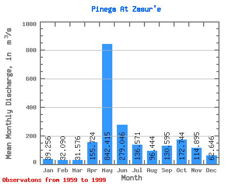
| Statistic | Jan | Feb | Mar | Apr | May | Jun | Jul | Aug | Sep | Oct | Nov | Dec | Annual |
|---|---|---|---|---|---|---|---|---|---|---|---|---|---|
| Mean | 39.26 | 32.09 | 31.58 | 155.72 | 842.41 | 279.05 | 136.57 | 96.44 | 130.59 | 172.74 | 114.89 | 62.65 | 174.50 |
| Standard Deviation | 9.07 | 6.64 | 6.95 | 171.03 | 242.11 | 120.58 | 77.56 | 73.64 | 67.60 | 80.98 | 52.01 | 26.31 | 28.29 |
| Min | 21.00 | 18.40 | 22.60 | 31.50 | 421.00 | 88.80 | 43.00 | 31.10 | 41.50 | 44.20 | 42.60 | 28.70 | 105.65 |
| Max | 68.90 | 43.00 | 50.40 | 729.00 | 1370.00 | 597.00 | 333.00 | 456.00 | 334.00 | 472.00 | 282.00 | 143.00 | 243.47 |
| Coefficient of Variation | 0.23 | 0.21 | 0.22 | 1.10 | 0.29 | 0.43 | 0.57 | 0.76 | 0.52 | 0.47 | 0.45 | 0.42 | 0.16 |
 Return to R-Arctic Net Home Page