|
|
|||||||||||||||||
| Point ID: 744 | Downloads | Plots | Site Data | Code: 07GB001 |
|
|
|||||||||||||||||
| Download | |
|---|---|
| Site Descriptor Information | Site Time Series Data |
| Link to all available data | |
| View: | Time Series | All |
| Units: | mm |
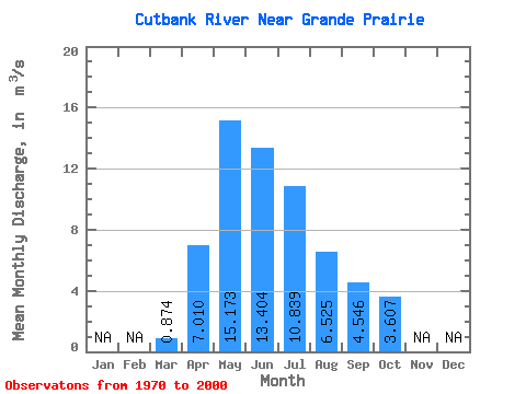
| Statistic | Jan | Feb | Mar | Apr | May | Jun | Jul | Aug | Sep | Oct | Nov | Dec | Annual |
|---|---|---|---|---|---|---|---|---|---|---|---|---|---|
| Mean | 0.87 | 7.01 | 15.17 | 13.40 | 10.84 | 6.53 | 4.55 | 3.61 | |||||
| Standard Deviation | 0.91 | 4.18 | 8.08 | 10.74 | 8.93 | 7.83 | 3.79 | 3.20 | |||||
| Min | 0.11 | 1.89 | 1.68 | 2.31 | 1.51 | 0.74 | 0.67 | 0.64 | |||||
| Max | 4.10 | 15.30 | 37.40 | 42.50 | 38.00 | 31.00 | 14.80 | 16.30 | |||||
| Coefficient of Variation | 1.04 | 0.60 | 0.53 | 0.80 | 0.82 | 1.20 | 0.83 | 0.89 |
 Return to R-Arctic Net Home Page