|
|
|||||||||||||||||
| Point ID: 7437 | Downloads | Plots | Site Data | Code: 70311 |
|
|
|||||||||||||||||
| Download | |
|---|---|
| Site Descriptor Information | Site Time Series Data |
| Link to all available data | |
| View: | Time Series | All |
| Units: | mm |
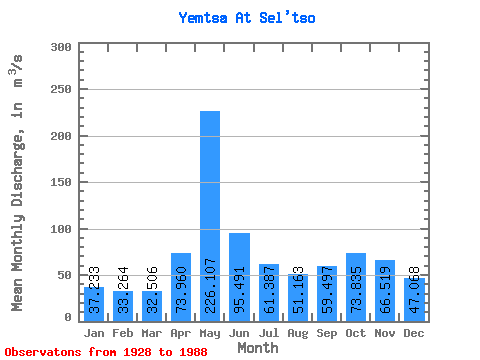
| Statistic | Jan | Feb | Mar | Apr | May | Jun | Jul | Aug | Sep | Oct | Nov | Dec | Annual |
|---|---|---|---|---|---|---|---|---|---|---|---|---|---|
| Mean | 37.23 | 33.26 | 32.51 | 73.96 | 226.11 | 95.49 | 61.39 | 51.16 | 59.50 | 73.83 | 66.52 | 47.07 | 70.66 |
| Standard Deviation | 4.99 | 3.53 | 2.48 | 45.93 | 69.42 | 25.12 | 21.19 | 16.17 | 23.20 | 26.92 | 19.72 | 10.16 | 10.66 |
| Min | 30.00 | 27.60 | 27.60 | 30.90 | 82.00 | 50.10 | 37.80 | 31.30 | 34.70 | 37.00 | 34.10 | 33.00 | 50.51 |
| Max | 50.70 | 41.80 | 37.60 | 217.00 | 390.00 | 153.00 | 134.00 | 105.00 | 137.00 | 132.00 | 102.00 | 73.00 | 90.47 |
| Coefficient of Variation | 0.13 | 0.11 | 0.08 | 0.62 | 0.31 | 0.26 | 0.34 | 0.32 | 0.39 | 0.36 | 0.30 | 0.22 | 0.15 |
 Return to R-Arctic Net Home Page