|
|
|||||||||||||||||
| Point ID: 743 | Downloads | Plots | Site Data | Code: 07GA002 |
|
|
|||||||||||||||||
| Download | |
|---|---|
| Site Descriptor Information | Site Time Series Data |
| Link to all available data | |
| View: | Time Series | All |
| Units: | mm |
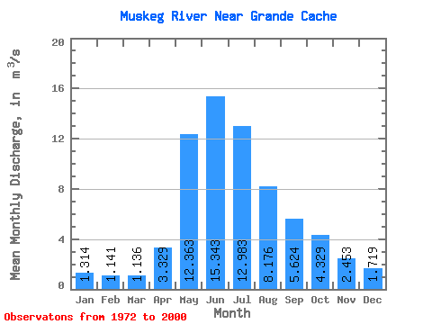
| Statistic | Jan | Feb | Mar | Apr | May | Jun | Jul | Aug | Sep | Oct | Nov | Dec | Annual |
|---|---|---|---|---|---|---|---|---|---|---|---|---|---|
| Mean | 1.31 | 1.14 | 1.14 | 3.33 | 12.36 | 15.34 | 12.98 | 8.18 | 5.62 | 4.33 | 2.45 | 1.72 | 5.90 |
| Standard Deviation | 0.32 | 0.28 | 0.40 | 1.33 | 5.17 | 8.24 | 8.17 | 6.62 | 3.16 | 2.25 | 0.72 | 0.52 | 1.67 |
| Min | 0.62 | 0.59 | 0.56 | 0.86 | 3.14 | 6.07 | 3.71 | 2.43 | 1.61 | 1.54 | 1.07 | 0.80 | 3.58 |
| Max | 1.96 | 1.60 | 2.71 | 5.67 | 25.00 | 42.10 | 39.90 | 31.10 | 12.60 | 10.10 | 3.48 | 2.53 | 8.83 |
| Coefficient of Variation | 0.25 | 0.24 | 0.35 | 0.40 | 0.42 | 0.54 | 0.63 | 0.81 | 0.56 | 0.52 | 0.29 | 0.30 | 0.28 |
 Return to R-Arctic Net Home Page