|
|
|||||||||||||||||
| Point ID: 7418 | Downloads | Plots | Site Data | Code: 70270 |
|
|
|||||||||||||||||
| Download | |
|---|---|
| Site Descriptor Information | Site Time Series Data |
| Link to all available data | |
| View: | Time Series | All |
| Units: | mm |
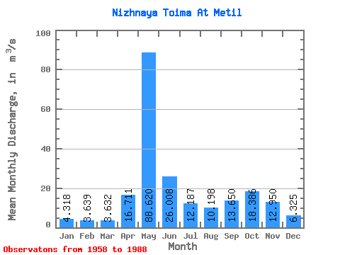
| Statistic | Jan | Feb | Mar | Apr | May | Jun | Jul | Aug | Sep | Oct | Nov | Dec | Annual |
|---|---|---|---|---|---|---|---|---|---|---|---|---|---|
| Mean | 4.32 | 3.64 | 3.63 | 16.71 | 88.62 | 26.01 | 12.19 | 10.20 | 13.65 | 18.39 | 12.95 | 6.33 | 18.02 |
| Standard Deviation | 1.33 | 0.85 | 0.81 | 20.56 | 26.24 | 13.69 | 6.63 | 7.01 | 6.83 | 8.69 | 7.53 | 3.04 | 3.41 |
| Min | 2.60 | 2.35 | 2.27 | 2.77 | 36.90 | 8.35 | 4.85 | 3.84 | 4.75 | 6.18 | 3.62 | 3.40 | 10.48 |
| Max | 8.30 | 5.90 | 5.65 | 100.00 | 150.00 | 63.80 | 28.00 | 33.30 | 31.90 | 46.50 | 32.80 | 14.80 | 25.02 |
| Coefficient of Variation | 0.31 | 0.23 | 0.22 | 1.23 | 0.30 | 0.53 | 0.54 | 0.69 | 0.50 | 0.47 | 0.58 | 0.48 | 0.19 |
 Return to R-Arctic Net Home Page